Township hears concerns about algae as water level drops in Lake Huron
Huron-Kinloss council was updated about concerns that algae will become more prevalent along the shores of Lake Huron as the water level drops to near what it was 15-20 years ago.
The information was brought forward by community services director Mike Fair in a report to council in committee-of-the-whole, Monday, Jan. 12.
The lakeshore environmental year-end summary included details about algae, phragmites, tree permits and lake levels.
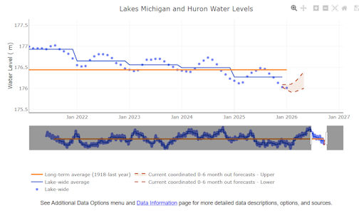
Fair reported that graphs indicate the lake level is falling to near 2002-12 levels. If the lake level goes down this low, an increase in algae production is anticipated for 2026. Last year, staff received one complaint regarding algae wash-up in Huron-Kinloss.
Fair said algae clean-up was scheduled at regular intervals in 2025, and the total contracted budget was $20,000. The schedule began in May with a complete shoreline clean-up and continued bi-weekly until the end of June.
Clean-up was conducted weekly beginning in July with a primary focus on the Point Clark Lighthouse beach, Bruce Beach, and Lurgan Beach. Amberley Beach and Boiler Beach were visited but clean-up was often not required. The final shoreline clean-up was conducted at the end of September, for a total of 75 hours expended.
Fair reported that an industrial bin was placed at the Point Clark Lighthouse parking lot during clean-ups to reduce the transportation costs associated with disposing of algae.
As to the invasive phragmites (common reed), staff spot-sprayed the lakeshore as required in late May and June to control phragmites which is starting to re-emerge, said Fair.
With regard to lakeshore projects, the township installed and maintains sand-dune fencing along exposed erosion-prone sections of Boiler Beach, and completed planting projects to mitigate the same erosion, with more than 200 additional spruce and junipers.
Community services staff partnered with the Pine River Watershed Initiative Network (PRWIN) and local residents to plant another 100 junipers along Bruce Beach to stabilize the shoreline and prevent sand from drifting off the beach.
The best management practices guide for living on/near the lakeshore was distributed to all lakeshore residents and continues to be a helpful tool for guidance along the shoreline. The guide can be found on the Huron-Kinloss website at
www.huronkinloss.com/media/ijwo0031/shoreline-best-practices-guide.pdf.
As to the water level in Lake Huron, the Great Lakes Environmental Research Laboratory is an effective resource that provides up-to-date information about the Great Lakes and factors that influence lake levels. Below, is the water levels for Lake Huron, including the historical 1918-2023 graph and 2020-25 graph, as viewed on
www.glerl.noaa.gov/data/wlevels/dashboard/.
The National Oceanic and Atmospheric Administration generates a Great Lakes dashboard project that acts as a multi-agency gateway to long-term, basic-scale hydrological and climatological data for the Laurentian Great Lakes. This link leads to real-time data on water levels and hydroclimate of Lake Huron and the other great lakes:
www.glerl.noaa.gov/data/wlevels/dashboard/#longterm.
Huron-Kinloss committee-of-the-whole approved Fair's report.
 Written By
Liz Dadson is the founder and editor of the Kincardine Record and has been in the news business since 1986.


Related Stories
No related stories.